
This land area calculator finds the area of a plot from the coordinates of its corners, using the shoelace (coordinate) method. Paste eastings and northings from a survey plan or a total station, one corner per line.
You get the area in m², hectares, acres and ft², in Nepal’s ropani-aana-paisa-daam and bigha-kattha-dhur systems, the perimeter, and the length and whole-circle bearing of every boundary line. A sketch of the plot shows at a glance if a corner is out of order.

Site Engineer Pocket Reference
A free 7-page PDF with the site numbers you use most.
Useful for this job
We may earn a commission if you buy through these links, at no extra cost to you. As an Amazon Associate, EducateLink earns from qualifying purchases. Disclosure
How to use it
- In Corner coordinates, one point per line (Easting, Northing or X, Y), enter each corner as two numbers separated by a comma, space or tab.
- List the corners in order around the boundary, clockwise or anticlockwise. There is no need to repeat the first point at the end.
- Set Coordinate units to metres or feet. Feet are converted to metres before the area is worked out.
- Check the sketch: the outline should not cross itself, and the corner numbers should run around the edge.
- Read the area, the ropani and bigha breakdowns, the perimeter and the boundary lines.
How the area is calculated
The shoelace formula works through the corners in order, with the last corner joined back to the first:
A = ½ |Σ (Ei × Ni+1 − Ei+1 × Ni)|
The sign of the sum only tells you the direction (negative means clockwise), so the tool takes the absolute value.
- Side length = √(ΔE² + ΔN²). The perimeter is the sum of the sides.
- Bearing = arctan(ΔE / ΔN), placed in the right quadrant and measured clockwise from grid north, 0–360°.
- Ropani system: 1 ropani = 16 aana = 5,476 ft² (508.74 m²), 1 aana = 4 paisa, 1 paisa = 4 daam, so 1 ropani = 256 daam of 21.390625 ft².
- Bigha system: 1 bigha = 20 kattha = 72,900 ft² (6,772.63 m²), 1 kattha = 20 dhur, so 1 bigha = 400 dhur of 182.25 ft².
The tool converts the whole area into the smallest unit (daam or dhur), rounds it to 0.01 and carries upward. The larger units are whole numbers, and a remainder that would round to 4.00 daam becomes one more paisa.
Worked example: four-corner plot
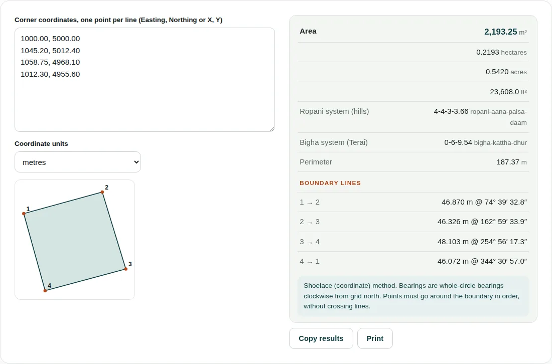
Corners: 1 (1000.00, 5000.00), 2 (1045.20, 5012.40), 3 (1058.75, 4968.10), 4 (1012.30, 4955.60).
- Cross products EiNi+1 − Ei+1Ni: 1→2 = −213,600.00; 2→3 = −114,220.38; 3→4 = +217,533.87; 4→1 = +105,900.00.
- Sum = −4,386.51. Area = 4,386.51 / 2 = 2,193.25 m². The minus sign shows the corners run clockwise.
- 2,193.25 / 10,000 = 0.2193 ha; 2,193.25 / 4,046.856 = 0.5420 acres; 2,193.25 / 0.092903 = 23,608.0 ft².
- Ropani: 23,608.0 / 21.390625 = 1,103.66 daam. 1,103.66 / 256 = 4.31, so 4 ropani, leaving 79.66 daam. 79.66 / 16 = 4.98, so 4 aana, leaving 15.66. 15.66 / 4 = 3.92, so 3 paisa, leaving 3.66 daam: 4-4-3-3.66.
- Bigha: 23,608.0 / 182.25 = 129.54 dhur. That is under 400, so 0 bigha. 129.54 / 20 = 6.48, so 6 kattha, leaving 9.54 dhur: 0-6-9.54.
- Side 1→2: ΔE = 45.20, ΔN = 12.40, length √(45.20² + 12.40²) = 46.870 m and bearing arctan(45.20 / 12.40) = 74° 39′ 32.8″. The four sides add up to a perimeter of 187.37 m.
Before you rely on the area
- Order matters. If two corners are swapped, the outline crosses itself and the area is wrong with no warning, so always look at the sketch.
- The result is the horizontal (plan) area from grid coordinates. It is not the surface area of a sloping plot, and no grid scale factor is applied.
- Curved boundaries need extra points along the curve. With only the two ends of an arc, the tool measures the straight chord.
- Latitude and longitude in degrees will not work. Convert them to projected coordinates in metres, such as UTM or your national grid, first.
Questions people ask
How do you calculate the area of land from coordinates?
Use the shoelace formula: multiply each easting by the next northing, subtract the next easting times this northing, add the results all the way round and halve the absolute value. For the default four-corner plot the sum is −4,386.51, giving 2,193.25 m². The corners must be listed in order around the boundary.
How many square metres is 1 ropani?
1 ropani is 5,476 ft², which is 508.74 m². A ropani is 16 aana, so one aana is 342.25 ft² or about 31.8 m². A plot of 2,193.25 m² works out at 4 ropani, 4 aana, 3 paisa and 3.66 daam.
Can I use GPS latitude and longitude?
Not directly. The shoelace method needs flat grid coordinates in metres or feet, so convert latitude and longitude to UTM or your national grid first. Degrees typed straight in give a meaningless area.
Related tools
- Engineering Unit Converter: Stress, force, moment, flow, land area (incl. ropani and bigha) and more.
- Levelling (Rise & Fall): Reduced levels from staff readings with arithmetic check and misclosure.
- Earthwork & Excavation: Pit and trench volumes, and cut and fill from cross-sections.
Results are for estimating, checking and learning. Design work should be checked against the current code and your project specification, and signed off by a qualified engineer. See all 20 engineering calculators.